Burnett River and Tributaries Catchment Flood Study
Background
The Burnett River is located in the Wide Bay – Burnett region and has a catchment area of about 33,000 square kilometres. Major flooding in the Burnett River is relatively infrequent, however, under favourable conditions, heavy rainfalls can result in significant floods. During the major flood event of January 2013 and January 2022, significant flooding throughout the Burnett River catchment impacted homes, infrastructure and agricultural land.
In late 2023, the Queensland Government and the Queensland Reconstruction Authority (QRA) announced more than $18 million in funding for a range of flood studies and resilience projects across 36 Councils under the QRA’s Disaster Recovery Funding Arrangements. Under this funding arrangement, the Burnett Catchment Council’s Working Group (comprising Bundaberg Regional, North Burnett Regional, South Burnett Regional, Cherbourg Aboriginal Shire, and Gympie Regional Councils) are working together to deliver the Burnett River and Tributaries Catchment Flood Study (The Flood Study).
The purpose of the Flood Study is to provide a better understanding of flood behaviour throughout the Burnett River catchment which, in the future, will be used to improve flood management and response and provide up-to-date information for land-use and infrastructure planning.
The Flood Study will be carried out over the next two years and the community will be invited to share their knowledge and experiences related to floods in the catchment throughout the Flood Study.
Timelines
The Flood Study will be carried out over the next two years and the community will be invited to share their knowledge and experiences related to floods in the catchment throughout the Flood Study.
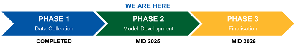
With Phase 1 complete, we can now proceed with Phase 2 – Model Development. Here, we will be recreating past floods using flood models of Boonara and Nangur Creeks and testing if they can predict floods accurately.
Community feedback
To ensure these flood maps represent what actually happened, we need your help! Have your say and help us get it right.
How to provide feedback?
- Online - Head to our dedicated Burnett River and Tributaries Catchment Study webpage here.
- Community Drop In Session
- Goomeri Library
- Thursday 1 May 2025, 1pm – 4pm
- No RSVP required